


Hurricane watch issued for Kings County
Tropical storm warning for Prince and Queens
Rainfall warning issued for Prince and Queens
Wind and storm surge warning issued for all of PEI
There could be localized flooding in low-lying areas.
Possible washouts near rivers, creeks and culverts.
Storm surge most likely for parts of the Gulf of St. Lawrence Saturday evening and overnight. There could be coastal damage. Stay away from all affected shorelines.
Expect more rain in Prince and Queens Counties and stronger wind in Kings County.
WHAT TO EXPECT
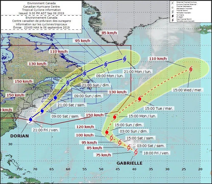
Dorian will still be a Category 2 hurricane when it crosses over the Maritimes Saturday. The eye will be over Halifax. It may also be a Category 1 as it passes over eastern PEI. A Category 1 has sustained winds of 119 KM/H.
Another source is saying it will be a Category 2 which would have winds of 160 KM/H and passes through eastern Nova Scotia. It will be a Category 1 in eastern Kings County. Tropical storm status for the rest of PEI.
Heavy rain will also be an issue. 40-60 mm in total expected. 20-30 mm in the afternoon and evening for all of PEI and possibly 20-30 mm overnight. 10-20 mm of rain for eastern PEI overnight.
For central and western PEI winds will see gusts to 80 K by late afternoon and 90 K by night. Gusts in eastern PEI could reach 110 K.
Dorian will begin to have its heaviest rain and wind in the afternoon and overnight.
—
There will be a technical meeting briefing on Hurricane Dorian in a teleconference with the media Saturday morning from the Canadian Hurricane Centre at 10 a.m. Ocean 100 will provide you with information as it happens.
Ocean 100 will have live coverage throughout the weekend.
HEALTH EMERGENCIES
Health PEI would like you to call ahead if you plan to visit any primary care or mental health walk-in clinics this weekend or if you have a scheduled appointment.
The weather may impact walk-in clinics and other medical appointments.
—
TRAVEL

All Northumberland Ferry crossings at Wood Island and Caribou are cancelled Saturday due to the expected storm.
Service disruptions are also expected Sunday. It’s likely ferry service will not resume until Sunday afternoon at the earliest based on the weather forecast.
—
There is a wind warning advisory on the Confederation Bridge between 4.00 Saturday afternoon and 4.00 on Sunday afternoon.
Traffic restrictions may be put in place depending on wind conditions.
—
Some flights at the Charlottetown Airport are already cancelled. Call ahead to your carrier before heading to the airport.
—
MARITIME ELECTRIC READY
Power outages will be a big concern this weekend. Kim Griffin at Maritime Electric says crews and emergency crews are ready and have been preparing for days. She says the big concern will be downed power lines with high winds and leaves still on tree branches.
Emergency crews will be ready to go in any case throughout the storm.
SHELTERS IN CHARLOTTETOWN
The City of Charlottetown and the Emergency Measures Organization ask you to prepare an emergency kit that will last for 72-hours. It is important to include medications with your kit.
Fire Chief Randy MacDonald says his department will be ready for any emergencies throughout the weekend.
A public shelter will open at Jack Blanchard Hall, located near Colonel Gray High at 7 Pond Street beginning at noon Saturday and will be open to anyone who is experiencing homelessness during the storm. The shelter will remain open until noon on Sunday.
Food will be provided by the Upper Room Soup Kitchen along with sleeping bags and pillows.
Bedford-MacDonald House will be open throughout the weekend. Blooming House will open at 4.00 Saturday afternoon.
The West Royalty Community Centre will also be open as a shelter.
You can go to www.charlottetown.ca/news for more information on shelters.
The Water and Sewer Utility and essential City services have back-up power and the goal is to continue to provide services. You should keep water and other supplies at hand.
To report a water main break, fire hydrant issues and sewer backup call 902-626-6916.
If there are downed trees, a catch basin problem or any city infrastructure problem call 902-629-6916.
All other emergencies will require you to call 911.
You can also go online at https://www.charlottetown.ca/contactus
HURRICANE JUAN 2003
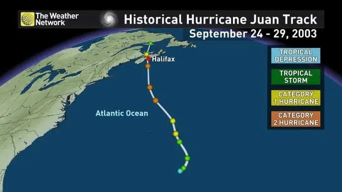
Sixteen years ago, Hurricane Juan hit the Maritimes traveling through Halifax, Truro, then crossing the Northumberland Strait and hitting Charlottetown and parts of Queens County. The date was Monday, September 29, 2003.
The Category 1 storm did major damage at the Charlottetown Yacht Club and Marina and downed dozens of trees and power lines.
It hit about 3 a.m.
There was a lot of damage but thankfully no fatalities.
And the same day, Islanders went to the polls in a provincial election.
—
OCEAN 100 STORM CENTRE
Some cancellations already.
You can go to http://bit.ly/Ocean100StormCentre to submit a cancellation.
Harness racing at Red Shores in Charlottetown has been cancelled today due to Dorian.
The Sunday afternoon program at Red Shores in Summerside has been moved to 4.00 with updates to follow.
The visit of the Christopher Columbus replica ship the Santa Maria in Georgetown port set for Saturday and Sunday is cancelled.


